Tramway Wharf and its related industries
This walk is focused around the Marple tramway Upper Wharf, its role in the completion of the Peak Forest Canal and the associated cargoes it would have carried.
(1) The route starts with parking on Strines Road, alongside Marple recreation ground.
(2) After crossing the road, walk through the site of Oldknow’s limekilns. The interpretation board here has a good artist’s impression of how the kilns used to look as well as an interesting period plan showing the lime kilns and associated buildings in relation to Samuel Oldknow’s private basin and wharves on the upper level of the canal.
Limestone and lime was the primary reason for the construction of the Peak Forest canal. With the industrial revolution in full swing its uses in agriculture (for soil stabilisation and fertilisation) and construction (for mortars, paints and cements) were in high demand as well as its use as a high quality building stone. This canal was designed to bring primarily lime, as well as coal and gritstone, from the quarries of Derbyshire through the Bugsworth canal basin complex and onwards to Manchester. When the railways developed, transport by train became practical via an interchange at Guide Bridge near Ashton-under-Lyne.
(3) Walking up Lime Kiln Lane towards Top Lock we can take a detour back to the Forces and Social Club (previously the British Legion building), sited now near the two canal arms which ran from Oldknow’s private basin directly into unloading sheds for the kilns themselves. Three or four depressions in the ground mark the tops of some of the kilns. Here also the Peacock Pit was sunk in 1860, a 38 yard deep coal mine intended to cut transport of coal for the kilns down to a bare minimum. This pit was worked until 1893.
The basin is still designated as private water, much as it was when built, and is not managed by the Canal and River Trust.
(4) Return to Lime Kiln Lane now and go via Top Lock onto the bridge at Marple Junction. Observe the grassy embankment which now forms the lawn for Top Lock House and the bank of the moorings in the basin. This was once the site of Oldknow’s boat building yard, with the manager living in the house. Behind the house and workshops there was a dry dock for boat repairs. In about 1840 the yard changed hands to James Jinks and his family ran it until about 1935, building and maintaining the wooden horse-boats for which this canal was designed.
Etchings of the front and back of Jinks' Boatyard. Notice the dry docks at the back.
Turning around to look at the Macclesfield Canal, we can see the Marple Wharf and warehouse stretch out before us, still in use as a loading wharf and a facilities block for boaters. The Canal and River Trust is currently applying for planning permission to redevelop the site and a local group is hoping to develop the warehouse for the benefit of the community. This canal was not built until about forty years after the Peak Forest Canal. The narrow section of canal here is the remains of a stop lock, put in place to ensure that water meant for the Peak Forest Canal was not lost into the waterway of another company!
This bridge is of a type that the Peak Forest and Macclesfield canals are famous for, known as a changeover bridge, and designed to allow the horse to follow the towpath over the bridge as it changes side but without its master having to unhitch the rope from the towed boat.
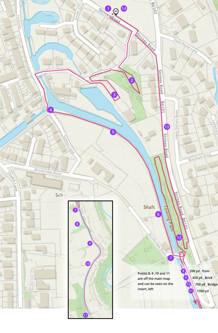
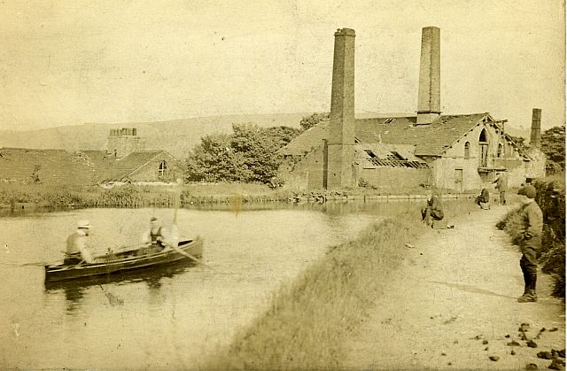
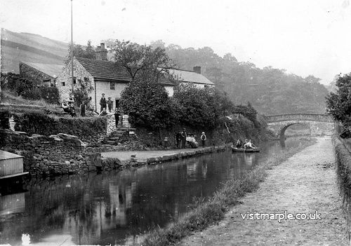
(5) Follow the towpath. On the other side of the canal you can see the roof of Bleak House, a private house on Strines Road. In the grounds of this house was the Mineral Mill and the two are shown in this old photograph. It was originally a steam-powered corn mill but was later converted to make various building products .
 Original mineral mill from canal, is shown left.
 The site today, with the same viewpoint, on the right. (David Burridge)
(6) Following the towpath we walk towards Brick Bridge and past the site of Barn Field pit, located right at the end of the field, beside the towpath and adjoining the garden of Churchgate Lodge. The site is clearly marked by the huge tree growing there. Another of Oldknow’s pits providing coal to fuel the lime kilns was Picky Wood pit, to be found just over the stile to the right as we reach Brick Bridge. Both of these pits were closed before 1872, probably soon after Peacock Pit was sunk.
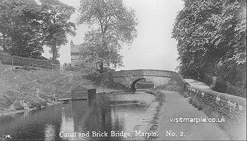 Brick Bridge(7) Brick Bridge, this too is a changeover bridge and was needed here because Samuel Oldknow stipulated that the towing path should always be on the west bank where it passed his land.
Almost every bridge on this canal was built from stone, as this was the accepted and available building material of the area. Brick Bridge is the exception. When building the canal, the company paused construction in order to raise additional finance for the flight of locks. It had already bought a large consignment of bricks for the locks. With funds low and the lock construction postponed, this valuable material was diverted into the construction of bridge 19. It was extensively rebuilt in 1981.
As we walk round the curve of Brick Bridge we can see the gates to Tramway Wharf. Built in 1798 this was originally the site of the upper wharf for a temporary tramway which connected the upper and lower levels of the Peak Forest Canal while funds were being raised to build the flight of 16 locks for which Marple is now famous.
I bought the site last year and hope to restore key historic details of the site including the embankment, some of the track, carriages and craning apparatus in order to better communicate some of the special but little-known history of the site. I hope the Wharf will provide an accessible space that facilitates projects which benefit the community with a special focus on historic awareness, education and creativity and would like to offer space for visiting historic boats to moor, recreating a wharf scene befitting of Marple’s rich industrial heritage. We will come back to the Wharf later to look at some of the features in more detail.
(8) Continuing along the towpath we walk on the opposite side to a field which leads us to the unfortunately named ‘Arm Pit’. Can you spot the well-trodden path still visible all these centuries after it was last worked? It is about 150 yards from Brick Bridge. In a natural valley in the field, now packed with trees, one can just make out where the short arm, just large enough for one boat, would have been. The boats would have loaded here before making the short journey to the lime kilns and back.
If you feel energetic you can carry on, first to Hilltop Bridge (34 chains or 748 yards) and then on to Plucks Bridge (sometimes known as Rawton Walls bridge), a further 28 chains or 616 yards. On the way to Hilltop you pass a milestone with the distinctive curved top that was the standard Peak Forest design. This one marks 8.5 miles from Portland Basin. The previous one was at Lock 15 (8 miles) and the 9 mile marker is just before Plucks Bridge. Note that the half mile markers are considerably smaller than the milestones.
(9) About 300 yards before Hilltop Bridge the canal narrows to allow stop planks to be placed for maintenance and repairs. This is Ratcliffe’s Stop Place.
(10) Hilltop Bridge is now a footbridge but it was originally a swing bridge as can be seen by the stone abutments. The path it carries leads from Dingle on Strines Road up to Hilltop Farm and then Hawk Green.
 Plucks Bridge and "Ancoats School Country Home(11) The alternative name for Plucks Bridge is Rawton Walls Bridge, after Rawton (or Routing) Walls which is the name of the quarry near Ridge End. In one direction Plucksbridge Road leads down to Strines Road and then on to the Roman Bridge. On the Marple side of the bridge the road goes on to Ridge End and Turf Lea but there are two footpaths off to the right immediately after the bridge. They both lead up to the Ridge, emerging on either side of the Ridge Methodist Chapel. The nearer and steeper one is known as Jacob’s ladder.
At this point we are returning to Brick Bridge to have a closer look at Tramway Wharf but you can, if you wish, go on to New Mills along the towpath. To use boatmen’s jargon, it is the best part of a league (three miles) and you will pass six bridges before you get there.
(12) Returning to Brick Bridge we can enter Tramway wharf. From the very first coping stones, closest to Brick Bridge, notice the bored holes which, with an oak peg and iron spike, held the beds and 'rails' for the tramway along the very edge of the canal itself. More correctly known as a plateway, this tramway used 3-foot lengths of 1 inch thick 'L' section iron for its rails, within which the carriage wheels sat. At a marked coping stone near this end we can see a chiselled in abatement to allow a fork in the track. These are marked as ‘Area 1’ on the plan. 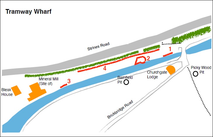
I hope to restore a length of this track, which would have continued on the slope down to Strines road, to house a reconstructed wagon similar to the one on display at Bugsworth basin.
The method of operation for this tramway was an early form of container shipping as we still see in use today. The full wagon bodies were loaded from the boats onto waiting chassis at the wharf and chained together in small group. These were sent down the tramway by gravity only, the speed being controlled by a 'ganger' and a lad who would lock or 'sprag' wheels with an iron hook on a chain to slow the wagons. Obviously health and safety wasn't what it is today. The empty wagons would then be hauled back up the slope by horse.
Walking along the wharf, these peg holes continue at their 3ft intervals until we reach an area of sunken coping stones with iron staples joining them together and many more holes in them,
‘Area 2.' This coincides with a substantial stone block at the back of the wharf and I am investigating whether this may in fact be part of a small 30 cwt crane. This would probably have been used for loading the empty wagon bodies back into the boats once they had been returned from the lower wharf. I am unsure whether this area would have sunk from the exertions of this crane or from mining subsidence as a shaft did run in this vicinity. A larger 3 ton crane, capable of lifting loaded wagon bodies, was also installed at the wharf and I am searching for evidence of its probable location.
You will be walking past a number of historic working boats moored at the wharf. I currently own three and hope that visiting historic boats will be able to stay and offer open days to show the unique history of each vessel. Negotiations with the Canal and River Trust regarding mooring at the wharf have taken a slow start but I am confident that the outcome will eventually be a good one.
A brief description of the boats here so far..
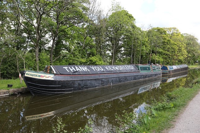 Prince & Yeo
Prince
Built in 1931 to carry goods from London to Birmingham on the Grand Union Canal. These boats were designed to go out onto the tidal Thames to load directly from the ships there. However their deep draught and deeper hulls made them impractical when fully loaded on the shallow canals and as such only 6 motor boats like Prince were made. Prince is the only surviving example of the two built by James Pollock and Son of Faversham, Kent.
Yeo
Built in 1959 by E.C Jones of Brentford. These boats represent the very end of canal carrying, a late 1950s attempt to streamline how goods were shipped by canal saw these 'River class' boats introduced on traffic in the south east. With their bluff lines and characteristic blue fibreglass covers these boats could hold more cargo and be loaded and covered in less time. However they were unpopular with the boat-people and were given the nickname of 'dustbin boats' or 'bluetops'. Within 3 years of Yeo being launched the harsh winter of 1962-3 effectively ceased most trade on the canals.
Ironsides Cargo carrying in Birmingham was a very different affair from the rest of the system. These boats were built to be towed in trains of up to 5 boats by a tug or team of horses and were known as 'joey boats' or 'day boats' because the people working them did not live aboard, instead only using them for the day.
This boat was built by Thomas Bantock in 1897 and used for maintenance and dredging after its coal carrying days were over. Named Cat by British Waterways in the late 1950s, we hope to restore her to original condition and possibly have her available to support community projects on the wharf if possible.
As we near the end of the wharf the plateway holes stop, denoting a change in track layout. At one point the track was doubled to allow more goods to be transshipped (at its peak 1200 tons a day) and plotting the route of the tramway along the wharf side is a particular interest of mine.
Area 3 The land ends at the edge of where the old mineral mill would have stood. It is thought that the original building on this site was a 'Summit warehouse' which was built to facilitate trans-shipment from the boats onto the tramway. After the tramway was broken up it was repurposed into a steam-powered corn mill and then further developed into Marple mineral mill after Oldknow’s death. We can now look down at Bleak House but this was only a minor building on the site in its heyday. The mineral mill was a large 4-storey mill reaching up from Strines Road to join the canal at the level of its upper two levels. By 1850 a tithe map shows the whole mill and tramway wharf as one site owned by Peter Arkwright. Another marked dig here shows a slab believed to be part of the path to the mill from the wharf.
As we walk back towards the entrance to Tramway wharf we can take a little turn down the actual slope of the tramway itself. Area 4. The impressive walled embankment has suffered over the 220 years since its construction but in some areas it is intact and at full height.
Turning back now we leave the wharf and take a left turn down the footpath to Strines road. Don’t forget to close the gate behind you.
This path is on the earliest OS maps and tithe maps from the early 1800s. I like to imagine workers for Picky Wood or Arm Pit, or indeed the tramway workers themselves, taking this same route.
Walk down Strines Road back towards the start point, you will see the slope of the tramway on your left and once you pass Bleak House the tramway would have actually been running down the road itself (or probably where the pavement now is!)
(13) This reconstructed picture shows what it would have looked like in the late Victorian period with Bleak House on the right and the four storey Mineral Mill on the left. 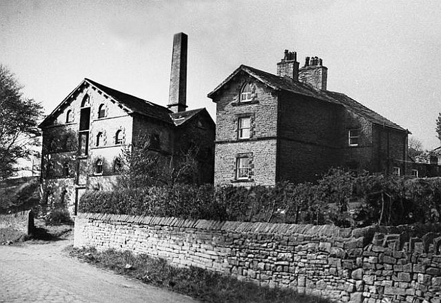 This image of the Mineral Mill (long demolished) as it would have been alongside Bleak House was created from two separate photos by Noel Brindley.
(14) Back to your parking place. If you look over the wall of the recreation ground you can make out the raised mound which peels away from the Strines road side and towards Oldknow road. This is the route of the tramway, still visible over two centuries later.
I hope you have enjoyed your walk around the Wharf. The work to restore it and to have it open to the public is taking longer than I had hoped. Negotiating with the Canal and River Trust as well as working to fund the bits I have done so far does take time! But, keep watching and we will see the wharf up and running soon enough! I hope next year to give you a guided tour of the Wharf and the tramway terminus.
View the PDF file for this walk here
Steve Gent : July 2020
