Maps showing proposed Boundary Changes : Marple & Mill Brow :2007
Dublin Core
Title
Maps showing proposed Boundary Changes : Marple & Mill Brow :2007
Description
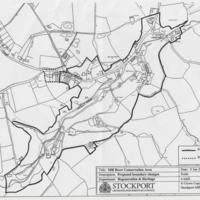
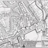
Two maps outlining the current conservation area boundary and proposed change. Dated 9th January 2007.
1. Station Road / Winnington Road Conservation Area
2. Mill Brow Conservation Area
1. Station Road / Winnington Road Conservation Area
2. Mill Brow Conservation Area
Publisher
Stockport Metropolitan Borough Council
Regeneration and Heritage Department
Regeneration and Heritage Department
Date
Reviewed AB 08/2022
Identifier
RHI/01/012
Louiset
Louiset
Hyperlink Item Type Metadata
URL
Go to Hyperlink below for article from MLHS website relating to Cheshire/Derbyshire boundarty changes
https://www.marplelocalhistorysociety.org.uk/our-local-heritage/derbyshire-or-cheshire.html?highlight=WyJkZXJieXNoaXJlIiwiY2hlc2hpcmUiXQ==
https://www.marplelocalhistorysociety.org.uk/our-local-heritage/derbyshire-or-cheshire.html?highlight=WyJkZXJieXNoaXJlIiwiY2hlc2hpcmUiXQ==
Collection
Citation
“Maps showing proposed Boundary Changes : Marple & Mill Brow :2007,” Marple Local History Society Archives, accessed May 2, 2024, https://www.marplelocalhistorysociety.org.uk/archives/items/show/1577.

