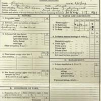
Cheshire Farm Survey 1941
Dublin Core
Title
Cheshire Farm Survey 1941
Subject
Photocopy of the Cheshire Farm Survey 1941 from Public Records Office.
Schedule of Farms in area plus Pie Chart showing number of Farmers/Employees and additional labour.
Schedule of Farms in area plus Pie Chart showing number of Farmers/Employees and additional labour.
Description
Includes Farms: Dawson; Sycamore, Hollywood End; Far Bradshaw; Upper Bradshaw; Spring-bank; Lower Bradshaw; Bradshaw Trees; Pistol; Gun; Shiloh; Norton Lee; Smooth Lea; Sportsman; Chatterton Lane; Hambleton Fold; Podnor; Lower Hall; Hill top; Cheetham Hill; Mellor Hall; Knowle; Townscliffe; Heathy Bank; Greenhill; Hollins Lane; Heys; Lea; Old Hall (Bottom's); Linnet Clough; Damsteads; Tarden; Longshaw Clough; Summit; Cannon Hill; Shirdfields; Whitehouse; Lower Birchenough; Higher Birchenough; Cold Wall; Cobden; Cobdenedge; Capstone; Lower Cliff; Bull Hill; Higher Banks; The Banks; Greenclough, Strawberry Hill; Lower Cobdenedge; Lower Stirrup; Higher Stirrup; Boarfield; Whitebottom; Hillside; Cowheys; Lane Ends; Greengate; Cloughend; Smithy Lane; Brook Bottom; Broadstone; Sun Hill.
Identifier
AGR/01/02
Louiset
Updated 01/10/16 MarkW
Louiset
Updated 01/10/16 MarkW
Collection
Citation
“Cheshire Farm Survey 1941,” Marple Local History Society Archives, accessed May 3, 2024, https://www.marplelocalhistorysociety.org.uk/archives/items/show/300.

