
Following the brief, but important, AGM, Ruth Hargreaves and Ann Hearle gave an insight into the five year project to study Longhurst Lane, work undertaken by a dedicated team of volunteer researchers , to create the story of Moor End to Marple Bridge.
Those long, long summer evenings, don’t you just love ‘em? Taking a languid rest in the cool of the day, with the sun setting, takng time for that wee cool drink, nibble and chat, perhaps? But others choose to spend some of those precious hours a little differently, as Ann and Ruth explained.
For four summers a group of volunteers, led by Faith Cleverdon, a vernacular architecture expert, photographed and recorded all the buildings along Moor End Road and Longhurst Road from Five Lane Ends to Town Street.
Why carry out the survey, the raison d'etre? Because it had been included in a number of local history projects that formed part of the Lottery funded Mellor Project 2007-2009, which were not archaeological.
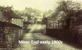 The 450 houses which were surveyed, along the 2 mile length of the road, a spine road, Mellor never having had a centre, formed a 200 year history. Houses varied from farms, mill workers cottages to Edwardian Villas, with some more modern properties interspersed.
The survey form used covered details of each property; date built (approx.), original use, house type, roof materials, roof shape, window shape, material, and glazing type, and genera ldescription. You may well ask if they had any problems, whilst wandering round the area with clipboards and highly ‘fashionable’ hi-viz vests? However, no hostility was met. Furthermore, once people had discovered why photographs and notes were being taken, many volunteered further information on their house and its history.
 Once the footwork had been done, over the course of three years of summer evenings or afternoons, once a week, the next question that arose was what to do with all the information gathered. What else could be simpler than to hold an exhibition? Not so simple !
The, by now, mammoth task continued to grow! Another summer was spent checking all the collected data. This was followed by a year of occupying of Tuesday afternoons with the adding historical data to the records. One small nugget of historical information, In 1907 the Stockport Advertiser reported ‘There is at present quite a little boom in building round about Marple Bridge and Mellor. Notice boards advertising land for sale 'on chief seem to be sprouting in nearly every field along Mellor-road and down in the adjacent valley known as The Bottoms, the site of an old cotton mill is offered for sale with a view to the erection of residential property thereon..’

The next task was to decide what to display? They decided on four maps to show the different periods in the life of the road, displays boards on pubs, farms and shops, any memorabilia, the work was hard with homework set each week. Old photographs would be shown. All in an effort to show the development of Mellor, through from is rural age to the industrial and beyond to its status as a commuter area.
The exhibition was held over the week-end of September 3rd & 4th 2011, at the Parish Centre, Mellor. A resounding success with more than 500 people visiting during the course of the two days.
Ann & Ruth’s talk was a smashing way to finish the Society’s season of talks. An enlightenment into a gargantuan task, a revelation of the history of 2 miles of road, and an entertaining evening.
(And with big thanks to Paul Rice for his work in organizing this season's of varied and rewarding talks)
